Content Standard for Digital Geospatial Metadata (CSDGM), Vers. 2 (FGDC-STD-001-1998) is the current version of this FGDC authored and endorsed standard. Executive Order 12906, directed that Federal agencies document geospatial resources using this standard. Since the publication of EO 12906, the FGDC has endorsed several ISO Geospatial Metadata Standards that are now encouraged for use.
Publications of the CSDGM Standard

Technical and Formal Publications
CSGM Profiles and Extensions
Formal, community-specific, customizations of the CSDGM. Extensions add elements to the standards. Profiles establish specific domain values for existing elements and may also add elements.
- Content Standard for Digital Geospatial Metadata: Extensions for Remote Sensing Metadata (pdf)
- Biological Data Profile of the Content Standard for Digital Geospatial Metadata (pdf)
- Metadata Profile for Shoreline Data (pdf)
Supporting Publications and Representations
- CSDGM HTML Version - the CSDGM Standard technical specification in an online format
- CSDGM Workbook - user-friendly presentation of the standard that explains the structure of the standard and format requirements. It includes example values, FAQs, and sample metadata records. This workbook is highly recommended for use in CSDGM metadata training and as a desktop reference guide.
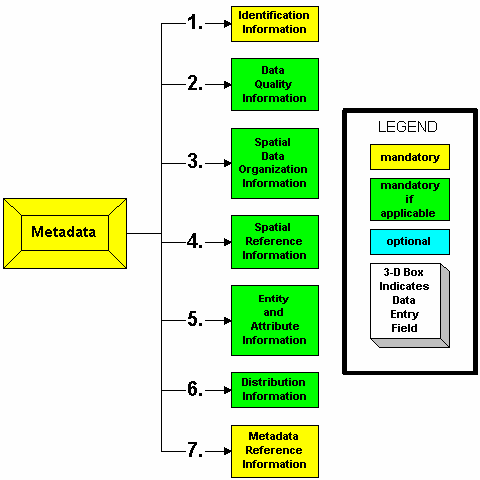
- CSDGM Graphical Representation - color-coded diagrams that provide a quick visualization of each section of the CSDGM, the elements contained within the section, and the conditionality of the elements. This is an excellent reference document for those familiar with the standard.
- CSDGM Document Type Declaration (DTD) - used to validate the CSDGM XML-encoded metadata format and value types.
- CSGDM XML Schema Document (XSD) representations - used to enforce specific content requirements of CSDGM XML-encoded metadata and associated profiles.
CSDGM Learning Resources and Guidance Documents
- Geospatial Metadata Quick Guide (CSDGM) – a short reference guide for writing quality CSDGM metadata
- CSDGM Essential Metadata Elements - A set of recommended metadata elements that can be used to as a boilerplate for the development of CSDGM organizational metadata and templates.
CSDGM Tools
Most GIS and image processing software application provide metadata editors and validators as components of their data management programs. The advantage of these data management systems in that the metadata is integrated into the data development and editing process.
The USGS Geology Program maintains a Metadata Information and Software site that provides:
- guidance on creating robust metadata
- downloadable metadata editor and validation applications
- online metadata validation
- online metadata component registries (USGS contacts and publication citations)
- online data dictionary and entity/attribute documentation
The following CSDGM applications are actively maintained:
- USGS Core Sciences (CSAS) Online Metadata Editor (OME)
The site presents a series of simple, jargon-free questions about your dataset and produce a standardized CSDGM metadata record. - USGS Metadata Wizard
An ArcGIS add-on application

